Although the Czech Republic cannot boast of enormous mountains or ski runs tens of kilometres long, the Czech mountains nevertheless have much to offer in winter. Last year, the operators of mountain resorts invested approximately CZK 400 million into modernising their technical equipment; this year, large investments are expected to increase the quality of the services provided.
Krkonoše needs no introduction
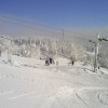
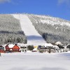
Špindlerův mlýn is the Czech Republic’s highest-quality and most-visited ski resort. Not surprisingly, therefore, it is also the venue of choice for many important sporting events. This year, the locals heeded a frequent suggestion of visitors and prepared to offer a three-hour ski pass. Skiers can also buy ski passes over the Internet for advantageous prices. The newest innovation can be seen in special state-of-the-art electronic entry gate signage at the entrance to the Hromovka and Svatý Petr – Pláň chairlifts. This provides current information on ski conditions.
The Horní Malá Úpa – Pomezky resort can boast the completion of a fully automated artificial snowmaking system and the SKiMU House restaurant directly on the trail. The Černá hora resort acquired for the new season six vending machines for returning chip cards.
Šumava invites families to ski with children
Špičák, Šumava’s most famous and largest ski resort, increased its ski area by one-quarter this year. Nevertheless, the prices of ski passes have not increased and a new service is offered such that, every Saturday, snow sport enthusiasts can use a regular bus line from Prague. The increased width of the pistes also allows for hosting international competitions. The Lipno ski resort has undergone extensive modernisation in recent years, and it now is mainly focused on families with children, beginners and school skiing courses. Youths up to 18 years of age can benefit from children’s rates for ski passes here.
Klínovec is the pride of Krušné hory
A brand-new, covered, 4-seat, express chairlift has replaced the Pařezová button lift at Klínovec. The entry station has been moved down the hill, thus extending the ski run and making it the longest on Klínovec. The resort also includes a mini area for beginners and families with kids, while the more advanced snowboarders can use a half-pipe.
The Bublava ski resort offers relaxed skiing, and mostly without waiting. There are wide trails at all levels of difficulty, a large range of time- and ride-based tickets, evening skiing, and a snow park with obstacles and jumps. The cross-border “Klingenthal – Bublava Skiregion” is being prepared at Bublava, thus joining the offer of skiing and related services on both sides of the state border.
Jizerské Mountains are dominated by Ještěd
The Ještěd peak is the gem of the Jizerské Mountains, with a view to Liberec and a broad panorama. The Ještěd ski resort is one of the most easily accessible. You can come to ski using the city of Liberec’s public transport or by car via the Prague – Liberec motorway. This year, a new Skiline service has been introduced which allows each skier to calculate the number of kilometres and elevation skied, and the number of rides on a particular ski lift based upon the ticket’s serial number. In cooperation with the Babylon Centre a popular combined ski and water park service is offered. For a very advantageous price you can buy a daily pass for the ski resort that is also a ticket to the water park. The ski resort is open from 8:30 a.m. to 4:00 p.m. and the water park from 10:00 a.m. to 8:00 p.m. The largest ski resort of the Jizerské Mountains is Tanvaldský Špičák, which offers 6 kilometres of ski runs of all difficulty levels and with artificial snowmaking along its entire course. Tanvaldský Špičák II is ideal for training young skiers. It is an enclosed area with a magic carpet, children’s ski lift and many attractions.
The Beskids have their own unique charm
You can enjoy good skiing even in Wallachia. One of the most popular resorts is Řeka, not far from Třinec. The operators of the Skialpin Pustevny resort have newly introduced ski buses for this season, transporting skiers directly to the main piste. Also new are tickets for senior skiers over 65 years of age, which sell for the same price as for a children’s ski pass. On Monday, 2 January, the Razula ski resort in Velké Karlovice kicked off its “Ski and Swim” bonus package, whereby skiers will obtain a free one-hour pass for the thermal pools of the Horal Wellness hotel. You can thus conclude a day spent at the slope by bathing in salt water heated to 36°C.
The Orlické Mountains keep up with their offer
Beautiful ski resorts also can be found in the Orlické Mountains. The Čenkovice resort is part of the Buková hora Ski Region, which is the largest ski resort of the Pardubice region and bears the “Czech TOP Resort” golden mark of quality. On offer are ski runs of easy and intermediate difficulty with total length of 4,000 metres. Eight lifts with total capacity of 4,400 persons per hour ensure smooth operation and skiing without long waits. The range of services also includes night skiing and a snow park for snowboard enthusiasts.
The Říčky ski resort on the south-east slope of Zakletý Hill is the best resort in the Orlické Mountains and one of the top ones in the entire Czech Republic, thanks to its elevation, state-of-the-art ski lift, as well as diverse and advantageously oriented pistes of varying length.
Although it opened just last year, the Červená Voda ski resort already has become highly popular among skiers. It offers the longest piste in the Orlické Mountains and a heated 4-seat chairlift with a protective shield so you no longer need to freeze on your way to the top. An innovation this year is radar allowing you to measure the speed at which you skim down the hill.
One of the most modern winter resorts can be found in Jeseníky
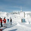
The cutting-edge Kouty nad Desnou ski resort is the largest downhill skiing resort in Moravia. It can boast the first 6-seat chairlift in the Czech Republic. Two of the four runs are more than 2 kilometres long and uniquely are more than 50 meters wide. The package of services on offer is complemented by a sunny terrace with Alpine-style buffet near the top station and several restaurants at the bottom.
The Bohemian–Moravian Highlands are cross-country paradise
While the Czech Republic has more than 200 ski resorts large and small with over 450 kilometres of maintained ski runs, you can also find more than 3000 kilometres of maintained cross-country trails. If you follow these into the countryside, you can absolutely rely upon the detailed trail-marking that is unmatched anywhere in the world. The Highlands with all their secluded and beautiful expanses comprise a cross-country paradise. You can also take along your cross-country skis to the peaks of all the Czech mountains already mentioned. There even are several inviting bobsleigh, toboggan and sled tracks. Most winter resorts provide information on the comprehensive portal.


 Česky
Česky Deutsch
 Español
 Français
 Italiano
 Nederlands
 Polski
 по-русски


 Ski centre
 Sports complexes
 Lower cableway station
 - restaurant


